Bird Taxidermy Migrates to New Home
Our bird taxidermy specimens are on the move! We’ve moved and unpacked 442 birds; that’s a lot of feathers! Now, our most fragile specimens are stored in a stable environment.
Mrs. Clarence Porter was tired of running. Maybe, like other African Americans during the Great Migration, she had fled the Jim Crow South. For whatever reason Mrs. Porter had run, on May 15th, 1973 she stood in front of the City Plan Board of Dayton, fighting to stay in in a small neighborhood known to locals as the East End. By her side were Herman Lander, Charles Stone, and Ruby Daniel, three community leaders who from 1971 to 1974 made regular visits to the City Commission to demand intervention. For more than forty years, their neighborhood had been in decline due to a zoning ordinance that opened the area to heavy industry. The East End was a rare pocket of racial diversity in the urban landscape, one of the oldest integrated areas in the city, a community in which, according to the Dayton Daily News, around 300 Black residents lived concentrated among the 60,000 whites of East Dayton. Also present in May of 1973 was a man by the name of John Hugh. He was the personnel director of a company called United Systems Corporation, a local company that produced the Digitech Datalogger, thermocouple thermometers, and about 150 local jobs. The citizens of the East End wanted to preserve their quiet residential haven, United Systems wanted a parking lot.
The story of the East End is important, but it is not unique. While the city of Dayton may not have intentionally wished the neighborhood harm, systems of redlining and zoning often had a devastating effect on Black communities across the United States. According to Richard Rothstein, research associate at the Economic Policy Institute and author of the book The Color of Law, “Not only were [African American] neighborhoods zoned to permit industry, even polluting industry…but [the plan commissions] prohibited these as zoning violations in neighborhoods where whites lived.” To understand what happened to the East End, we need to look beyond the individual players and instead to the relationships between whiteness and privilege, race and property.
Zoning was first developed at the turn of the 19th century to organize the landscape and protect residential spaces. By design, it aims for homogeneity. For example, in Washington D.C. in 1889, and along New York’s Fifth Avenue in 1907, height regulations stunted the growth of urban skyscrapers. These acts were intended to both beautify and to protect the cities’ citizens from destructive elements. In these cases, sameness was equated with both aesthetics and with order. Through the next decade, racial sameness was also preserved as cities began to zone away integration. Baltimore was the first American city to successfully zone for race, passing an ordinance in 1910 that restricted people from buying homes in which they were not part of the racial majority. Other cities followed suit, including Atlanta, Birmingham, Miami, Charleston, Dallas, and Louisville, Kentucky. In 1917, a Supreme Court case, Buchanan v. Warley, overturned Louisville’s ordinance. However, the court did not strike down the regulation on the basis of protecting African Americans, but instead on the basis of free choice. It was argued that these laws restricted property owners from selling to the buyer of their choosing. From this point, local governments got creative. In 1924, Richmond, Virginia passed a law prohibiting interracial marriage, and then used this concept to segregate residential areas. Citizens were only allowed to move to streets where they could marry a majority of people already living there. However, this law was challenged in court and rejected.
As racial zoning ordinances were repeatedly struck down in court, comprehensive zoning stepped in. It functioned to both protect whiteness and appropriate Black resources. Without directly offending the 14th amendment, it had a far more lasting legislative power. In 1926, a landmark case designed right here in Ohio, Euclid v. Ambler, set the generous parameters in which cities were allowed to regulate municipal spaces. The Cleveland suburb of Euclid was granted the right to block Ambler Realty Company from developing land for industrial uses. This also meant that city governments could allow industry where they pleased, including in areas where people already resided and these neighborhoods typically had at least one thing in common. Yale Rabin, visiting scholar at MIT, urban planner, and civil rights activist called this process expulsive zoning, which allowed “the intrusion into Black neighborhoods of disruptive incompatible uses that have diminished the quality and undermined the stability of those neighborhoods.” In practice, expulsive zoning is a racialized seizure of property from Black Americans.
Nothing in Dayton’s Zoning Code explicitly regulates or segregates race. In fact, it promises to protect every property owner within its borders. In 1930, six years after an ordinance created the City Plan Board, and four after that board developed the code, Dayton produced a multi-page pamphlet illustrating the importance of government regulation subtitled, “What the City Plan is/What it is Doing/And What It Can do for you and Your City.” Its contents provide passionate and utopic answers to complicated urban problems. On page 8 it reads, “The Zoning Ordinance protects every property owner, large or small, against a selfish neighbor or an unscrupulous builder who may want to increase his personal profits at his neighbor’s expense and at the expense of the Community. The Zoning Ordinance gives every property owner a security that has never been enjoyed generally. In short the Zoning ordinance paves the way for the development of our City into a more orderly and therefore more attractive, into a healthier, happier, and more prosperous community.” On the surface, this is far preferable to Birmingham’s reasoning, which in 1925 aimed to “protect the property holders against manufacturing plants and corner grocery stores which tend to spring up promiscuously about the city and to restrict the Negroes to certain districts.” However, the lack of clear racial language does not mean that zoning laws in the North were any kinder to African Americans. In fact, the East End’s story suggests that Dayton’s code had similar results of not only segregating residents, but of sacrificing Black health, safety, and financial stability to protect whiteness.
The heart of the East End was known as Irwin, generally situated between Springfield street to the North, Gaddis Boulevard to the South, Woodley Avenue to the East, and Irwin Street to the West, was initially zoned residential. It was home to African Americans, Eastern European immigrants, and white citizens since at least 1900, although oral tradition suggests it dates to the 1850s. Its proximity to the hydraulic race makes this date seem likely, since African Americans initially settled in East Dayton to build the canal. Herman Lander’s father Carl told the Dayton Daily News in 1973 that he remembered Irwin at the turn of the century, when livestock was herded down Springfield Street and coal taken to the nearby factories. Industry had long been a part of the Irwin landscape, but it wasn’t until the implementation of Dayton’s zoning code that the land actually belonged to it. When the region transformed from Residential B to Industrial A in 1931, the houses were no longer recognized as investments, assets, or even homes. They became instead “non-conforming structures” in the way of industrial expansion. Dayton’s zoning policy did not seek to protect this neighborhood, but rather to suffocate it, erase it, and leave fertilizer plants and stockyards in its place. The reasons for rezoning remain somewhat of a mystery. In 1931, the Plan Board reviewed a request from a man named Herman K. Bader to change the neighborhood’s status. A lovely, large map was drawn up with the suggested revisions, the blue dots you see denoting an industrial zone. The changes were approved and reflected in the ninth amended zoning map, in which the area was covered in a series of blue polka dots, almost like a legislative small pox denoting its “Industrial B” status.
Bader’s motivations were likely financial, but, they’re not entirely clear. He was a German immigrant, and appears to have come to Dayton to help his stepfather, a farmer named Frank Bruggeman, work the farm. The property was adjacent to large swaths of land owned by the Dayton Hydraulic Company, the largest of three hydraulic corporations in Dayton, and responsible for the headrace mentioned earlier. This company’s success was due largely to its ability to adapt. As waterpower made way for new technologies in the early 20th century, the DHC began aggressively leasing and selling the land to industry, a practice that relied on industrial zoning. In a letter to the Dayton Plan Board they argued that one specific area of the city had “no residential value whatever.” Whether Bader intended to sell the land to the DHC, lease to industries himself, or for some other reason entirely, it was at his urging that the neighborhood first transformed.
Although many Irwin residents wanted to stay, there were other factors at play that made it difficult and at times impossible for them to relocate. One of these influences was the process of redlining, a byproduct of the 1930s housing crisis, and was put in practice by two government agencies: The Home Owners’ Loan Corporation or HOLC, and the Federal Housing Administration, or FHA. While the former rescued existing mortgages nearing default, the latter issued new ones to eligible first-time buyers. Within the financially tumultuous atmosphere of the Great Depression, these investments were risky. Both organizations wanted some measure of financial assurance, which they sought through a system of appraisal. The HOLC enlisted local real estate agents to assess the value of American neighborhoods based on the level of protection against “unfavorable influences.” Their findings were translated into a set of over 200 easy to read, color coded maps, in which the safest areas were lush and green and the riskiest painted in red. In the descriptions that accompany each map, grade “D,” the lowest rating, is described as “characterized by detrimental influences in a pronounced degree, undesirable population, or an infiltration of it.” In 1937, the HOLC mapped Dayton, Ohio and drew red across Irwin’s borders. This act was justified by the neighborhood’s racial composition, as it hosted a population that was 80 percent Black. It is important to note the word choice on redlining documents, and that the land was described as being infiltrated by the poor and People of Color. In her article Whiteness as Property, Cheryl Harris explains that, “whiteness and property share a common premise – a conceptual nucleus – of a right to exclude.” So as the HOLC drew the color line across Dayton’s landscape, it prepared the FHA for a policy of whites-only mortgage lending. Unlike their predecessors, the FHA did not venture into redlined territory.
In 1968, the Fair Housing Act was passed to end the practice of redlining and promised to protect American citizens from racial discrimination. However, it did nothing to confront expulsive zoning. In fact, it was in this same year that another ordinance was passed in Dayton making it illegal for Irwin residents to repair or renovate their homes, since their status as non-conforming structures remained. Desperate for relief, they began taking proactive measures of preservation in 1971. Serious discussions of rezoning the region initially revolved around the Neighborhood Development Program, or NDP. This was one arm of Model Cities Program, itself an extension of Johnson’s War on Poverty. The NDP provided targeted areas with funds for rehabilitation. However, to be eligible for this money, the Irwin Area would need to be rezoned. Residents Herman Lander and Charles Stone were relentless in this fight, and when the neighborhood eventually lost out to West Dayton, they continued to push for residential zoning. Simultaneously, United Systems Corporation struggled to retain control of the area. It hoped to turn 14 parcels of land at the end of Diamond Avenue into a parking lot. The Dayton Plan Board and City Commission heard cases on both sides for the next two years. Stone even met with United Systems administrators on several occasions to investigate a compromise. Reverend Ruby Daniel explained to the Dayton Daily News why Irwin meant so much, why it was worth fighting for, describing it as one big family, with children coming to her porch daily for sweets from her candy shop. She was particularly motivated to fight the zoning for her church, the Daniel Temple of All Nations Holiness Church of God. Ruby wanted a steeple. When she initially applied for the permit, she was told to return with blueprints. But even after paying an architect $200 to have them drawn up, she was denied based on the area’s industrial zoning.
The three activists, Daniel, Lander, and Stone, navigated groups of Irwin residents through a series of public hearings and Plan Board meetings. Finally, in June of 1973, the City of Dayton awarded Diamond avenue residential status. However, this did not include the 14 parcels coveted by United Systems corporation. At a public hearing on September 5th, Irwin resident Robert Hand accused the Commission of speaking to them with forked tongues. Charles Stone said he felt they had been defeated. It’s clear that the Plan Board had catered to industrial desires in the name of preserving local jobs. However, according to the people of Irwin, United Systems Corporation did not employ African Americans, despite their residency in the only Black neighborhood in East Dayton.
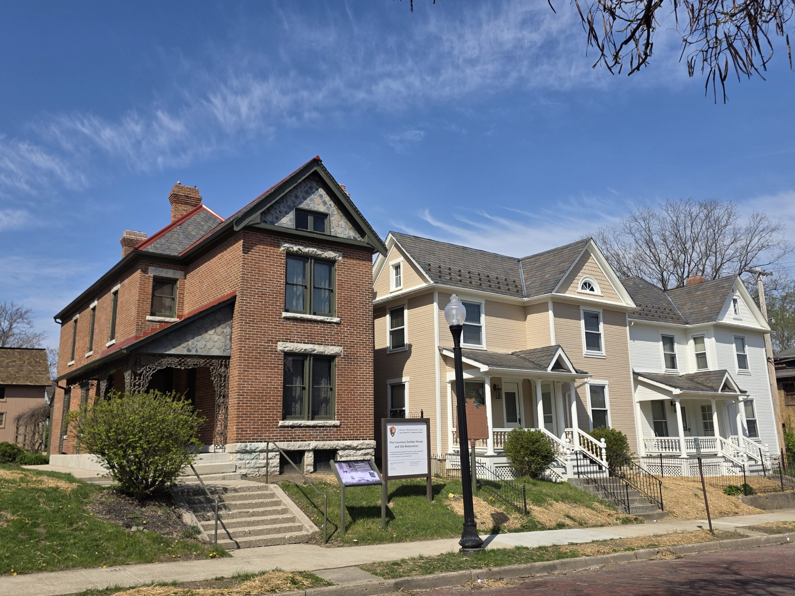
Ruby Daniel did not get her steeple. Her church sleeps quietly, its eyes shuttered with plywood. But Irwin has maintained its residential status, and although industry eroded many traces of the old neighborhood, pockets still breathe with life. At 1 Diamond Avenue is the Mt. Pisgah Baptist Church led by Dr. K. Edwin Bryant, an author and social justice advocate. Former residents of the East End, like renowned artist Bing Davis, still carry the spirit of the community in their hearts. At least once, some members of the community have reconvened for an East End reunion. The history of redlining and racially motivated zoning is an undeniable part of our American story, and we need to first acknowledge it before we can change it. But equally American is the story of Irwin and the residents of the East End who knew what they built was worth fighting for.
***
Additional Reading:
Harris, Cheryl. “Whiteness as Property.” Harvard Law Review Vol. 106, No. 8. Cambridge, MA: The
Harvard Law Review Association, June 1993.
Mt. Pisgah Church, “About.” https://www.mtpisgahdayton.org/bishop-k-edwin-bryant-2/
Rabin, Yale. “Expulsive Zoning: The Inequitable Legacy of Euclid.” In Zoning and the American Dream:
Promises Still to Keep eds. Charles M. Haar and Jerold S. Kayden. Chicago, Ill. : Planners Press, American Planning Association in association with the Lincoln Institute of Land Policy, 1989.
Rothstein, Richard. 2018. The Color of Law. New York, NY: Liveright Publishing Corporation.